
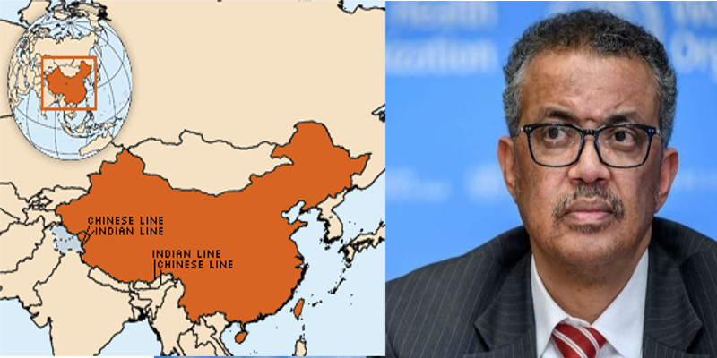
The World Health Organization (WHO) has made a blunder by depicting parts of India’s Ladakh as Chinese territory! A world map displayed in the website of the Chinese section of the organization shows parts of India’s Ladakh as Chinese territory. Interanational border disputes between the two asian giants came into effect since China’s invasion of Tibet.
Parts of Ladakh (Aksai Chin) is shown as Chinese territory by the Chinese section of the World Health Organization. Aksai Chin is a region administered by China as part of its Xinjiang and Tibet autonomous regions (mostly as part of Hotan County, Hotan Prefecture in Xinjiang), claimed by India as part of the union territory of Ladakh and constituting the eastern portion of the larger Kashmir region which has been the subject of a dispute between India and China since 1962.
In the wake of coronavirus pandemic, WHO has received intense criticism over being biased towards China. With the disastrous virus originating from China and the blunder of its regime not informing the world in time has led to the worst crisis on this earth! WHO is equally being criticized for being biased towards China during this global health hazard.
The incident is a clear indication of how effectively China influences WHO. Including an territory of international dispute into Chinese map is a clearly a narration of China. Recently, the digital version of Chinese map has included parts of India’s Arunachal Pradesh as Chinese territory. Sky Map (China’s authority on digital maps, is constructed and operated by a unit directly under Beijing’s National Surveying and Mapping Geographic Information Bureau) users discovered that it has updated the country’s map with the latest national borders, including India’s Arunachal Pradesh.
Arunachal Pradesh, a hill state in the Northeast bordering Tibet, was part of British India in 1913-14 and formally included in India when the McMohan Line was established as the border between India and Tibet in 1938. China has continuously been enforcing its claim of Arunachal Pradesh as a part of Tibet, which it occupied in 1951.


Leave a Reply